Announcement

Collapse
No announcement yet.

MH370 Malaysian missing plane conspiracy

Collapse
X
 
  • Filter
  • Time
  • Show
Clear All
new posts

  • MH370 Malaysian missing plane conspiracy

    Here's my theory.

    Americans did it to test China's military/satellite abilities.


    Evidence #1

    Among the passengers were 20 members of the Freescale Semiconductor company.

    A company specialized in radar technology.


    Evidence #2


    radar log :

    Malaysia Airlines MH370 Missing Playback Flightradar24 [14/03/08] - YouTube

    at 3.20 there's a plane that comes on to radar and by the speed it is going its very unusual and it also narrowly misses another plane

    probably an American jet fighter chasing the plane

    Evidence #3


    4000kms to the west of the last known position of the plane, Diego Garcia island is a US military base with GPS, echelon, fighter jets

    800km/h times 5h = 4000kms


  • #2
    Good theory but I believe it's a coverup story for Ukraine Russia crisis.

    It's to divert people's attention from the crisis because it could form into a potential WW3 and its better to avoid war.
    جی وا ترا بلوچ ، ذندان بلوچ ، کلو واتنییے
    G wa tra Baloch , Balochistan Zindabad

    Comment


    • #3
      in the plane were two iranian guys with fake passports
      faye's chauffeur

      Pashton's girlfriend

      I'm a Pashtun Princes


      Comment


      • #4
        Could all of you spread your stupidity somewhere else -_-

        Comment


        • #5
          That's a good theory, though the second one also has plenty of merit.
          Maybe it's BOTH at the same time !

          There are so many suspicious features of this event that
          any sane theory is not stupid, as said above, but evidence of people using their
          brains. Or intuition, or both, hopefully.

          Comment


          • #6
            Boeing 777-200 ER Dimensions


            777 reference size for scale


            This is one nautical mile with the 777 in the middle.


            That blue dot shows 1 square nautical mile in the original search area.


            Washington Post Infographic


            Comment


            • #7
              LOL @ conspiracy theorists
              [B]Almighty like nobody and nobody like Almighty[/B]

              Comment


              • #8
                Here is a timeline of events of the disappearance of Malaysia Airlines Flight 370. Times are local times.

                12:41 a.m. MH 370 departs Kuala Lumpur en route to Beijing. The plane has 7.5 - 8 hours of fuel.
                1:01 a.m. Plane reaches cruising altitude of 35,000 feet
                1:07 a.m. Last ACARS transmission. No further engine data is received after this time. The exact moment that ACARS is disabled is not clear. ACARS was disabled sometime between 1:07 and 1:37. Unclear which was shut off first, ACARS or transponder. The Malaysian government states: "We can say with a high degree of certainty that the Aircraft Communication Addressing and Reporting System (ACARS) was disabled just before the reached the East coast of Peninsula Malaysia".
                1:21 a.m. Transponder disabled. Plane last seen on civilian radar at 35,000 feet.
                1:22 a.m. - 1:30 a.m. First officer says "All Right, Good Night" right before being about to enter Vietnamese airspace (No exact time for this, this happens after transponder is shut off). Air traffic controllers lose contact with the plane. From this time, plane pings approximately once per hour, a total of 6 times. Data shows plane went west and then northwest, based on military radar coverage.
                1:30 a.m. - 2:15 a.m. Data from military radar. Plane climbs to 45,000 feet. Turns sharply to the west. Then descends unevenly to 23,000 feet as it approaches Penang. Plane then heads northwest. Please note, I cannot verify the accuracy of this altitude data. Radar data showing the aircraft’s altitude is based on primary radar return data that is known to be inaccurate at great distances from the radar ground stations, as is the case here.
                2:15 a.m. Plane is tracked heading toward waypoint Igrex. Possibly at 30,000 feet in Thai airspace. This appears to be last known contact with military radar.
                6:30 a.m. Originally scheduled landing time.
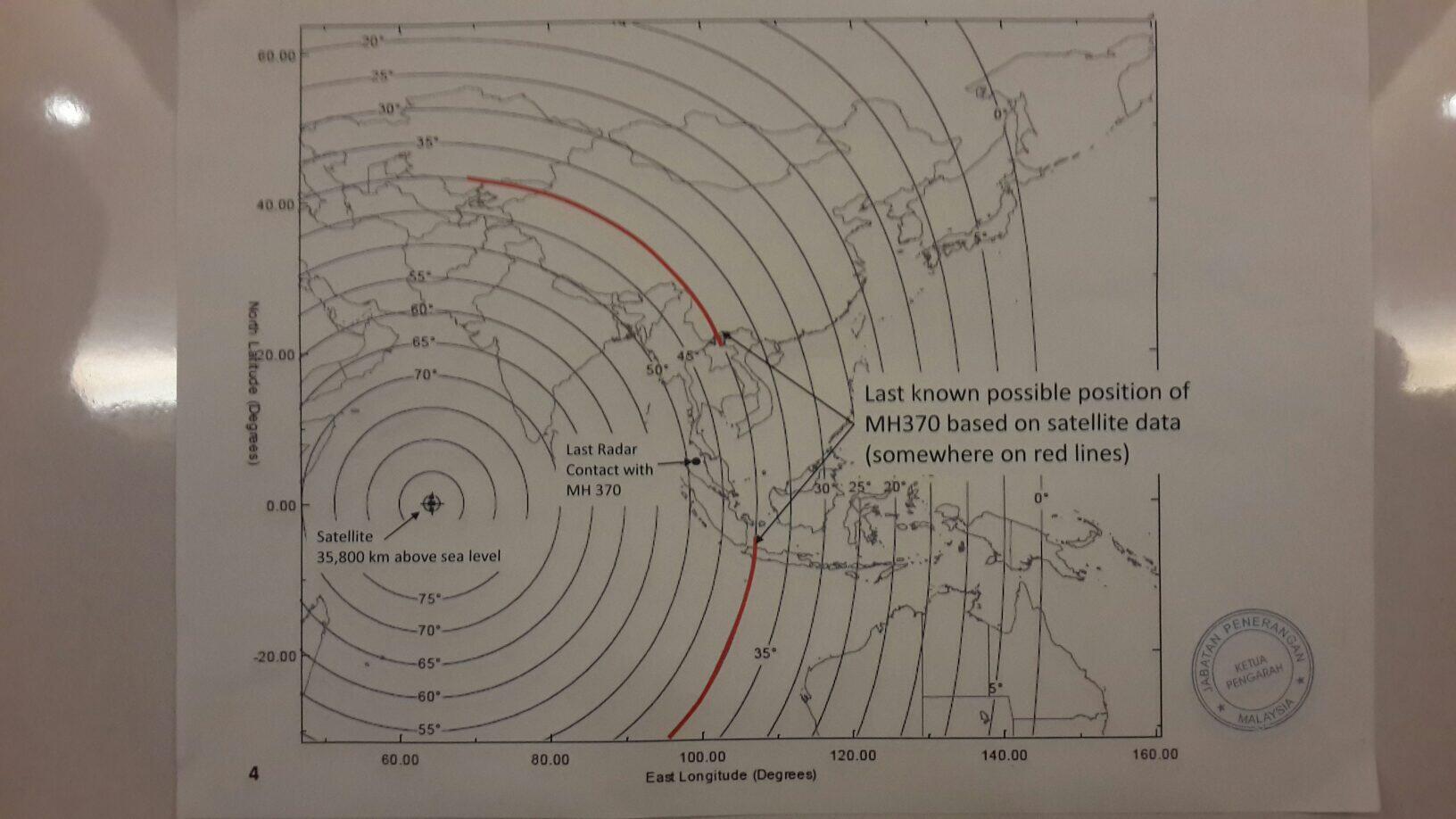
                8:11 a.m. (0011 GMT) Last confirmed communication between the plane and the satellite (i.e. last satellite ping). Unable to confirm precise location of the plane when it last made contact with satellites. The data did not show whether the plane was still flying or its location at that time, presenting searchers with a daunting array of possible last locations. Seven hours' more flying time would likely have taken it to the limit of its fuel load. However, the last communication of MH 370 was in 1 of 2 possible corridors: Northern (border of Kazakhstan and Turkmenistan to Northern Thailand) or Southern (from Indonesia to southern Indian Ocean). Map of last known location based on this data:

                Comment


                • #9
                  NBC Nightly News Synopsis – March 16th, 2014 6:30 PM EDT / 10:30 PM GMT / 6:30 AM MYT (+1 Day)
                  • Focus of investigation shifted to Pilots
                  • 25 Countries involved in the investigation (wow!)
                  • Malaysia has Requested sensitive Radar data from all countries
                  • Plane flew 7 hrs after transponder shut off (wow!)
                  • India and Pakistan are only countries so far to deny any breach of air space
                  • Indian Navy – suspending its search operations
                  • USS Kidd – continues searching in Bay of Bengal
                  • Expert opinion – Northern arc path is appearing pessimistic. Focus has shifted to Southern arc. It may never be found if it took the South Arc. It may take months for debris to show up on beaches.
                  • Black Boxes – The pinger only has a 30 day life – one third may have already been used up in the past 10 days.
                  •Families of passengers angry and exhausted. (Rightfully so!)
                  For the international crowd, NBC News is pretty good in the USA. Their sources are very reliable and usually have direct insider information (Like the Pentagon and DHS).


                  •Unidentified corpses in Meghna, Bangladesh

                  বাংলাদেশ ও বিশ্বের ব্রেকিং নিউজ সবার আগে পেতে ভিজিট করুন bdnews24.com. Read trusted, 24/7 live bilingual news, business, and entertainment updates

                  Comment


                  • #10
                    A man recites the Holy Qur'an after a special prayers held for the missing Malaysian airliner MH370 in Kuala Lumpur, Malaysia

                    Comment


                    • #11
                      Time Magazine:

                      Forget Australia, the Missing Jet May Have Crashed Near Bangladesh


                      A geological survey company says it has evidence suggesting that MH370 crashed off the coast of Bangladesh, not Australia


                      The hunt for missing Malaysia Airlines Flight 370 should turn several thousand kilometers from the southern Indian Ocean to the Bay of Bengal, say supporters of new evidence that could suggest that the doomed jet may have crashed around 190 km (120 miles) south of Bangladesh.


                      Australian company GeoResonance uses radiation scanning technology to locate significant concentrations of minerals and metals. By comparing images of the Bay of Bengal before and after the jet disappeared, the firm uncovered what it believes to be a sudden deposit of aluminum — the chief component of the Boeing 777 that vanished shortly after departing Kuala Lumpur on March 8 — along with titanium, jet-fuel residue and other key substances that may indicate the wreckage of a commercial airliner on the seabed.

                      Nothing has been confirmed, but the firm says that the technology has previously “been successfully applied to locate submersed structures, ships, munitions and aircraft.” It stresses that it “is not declaring this is MH 370” but that the findings should be investigated.

                      Malaysian acting Transportation Minister Hishammuddin Hussein says Malaysia is “working with its international partners to assess the credibility of this information.”

                      The Joint Agency Coordination Centre (JACC), which runs the search from Australia, has dismissed GeoResonance’s suggestion, with officials in Perth saying they are “satisfied” four signals detected in the Indian Ocean came from the black boxes of the missing aircraft.

                      Those signals were plotted along a corridor defined by analysis of maintenance data by British satellite firm Inmarsat. Hundreds of air and sea reconnaissance missions have been launched based on the analysis, making the search operation the most expensive in history. An underwater drone continues to operate along this route.

                      However, by Inmarsat’s own admission, the calculations that defined the southern search corridor had never been done before. The firm’s refusal to release raw data, despite repeated desperate pleas from distraught relatives, means the scientific community has been unable to critique or corroborate the findings.

                      Jules Jaffe, of the Scripps Institution of Oceanography, in California, tells TIME that he would like to think the Indian Ocean pings came from MH370, but: “One would really want to see the data to be more confident of that. I really hope that they have the quantitative analysis to back up their claims.”

                      There are difficulties with GeoResonance’s theory. While multispectral analysis has been used to discover subterranean mining deposits, electromagnetic radiation is absorbed by seawater, and many simply do not accept that it is capable of detecting a plane lying under a kilometer of ocean. David Gallo of the Massachusetts-based Woods Hole Oceanographic Institution, who co-led the search for Air France Flight 447, told CNN the data was “perplexing on a number of fronts.”


                      Nonetheless, GeoResonance says, “The company and its directors are surprised by the lack of response from the various authorities.”

                      * * * * * * * * * * * * * * * * * * * * * * *

                      Shukran ya Masr!!!

                      Thanks to Egypt for supporting Bangladesh against Pakistani harassment and support for terrorists and war criminals!!

                      Comment


                      • #12
                        Imagine all those people on board, all their hopes and dreams, all their fears and plans , all their worries for future and everything and suddenly no one can find their traces.

                        Life is like that, suddenly its all gone.

                        Comment

                        Working...
                        X